
Research Areas and Staff
Educational Staff
| Research Areas | Name | Academic Rank | Room | TEL |
|---|
Administrative/Technical Staff
| Name | Job Title | Room | TEL | FAX |
|---|
The area code is "81-86-251" in the following phone numbers.
Please add "@okayama-u.ac.jp" after the following mail addresses.
Takashi Kumamoto: Research Areas
Research Themes
1. Constructing the probabilistic seismic hazard map due to intraplate active faults
The aim of this study is to construct the probabilistic seismic hazard map for intraplate large earthquakes with magnitude 7.0 or over, such as the 1995 Hyogo-ken nambu earthquake, caused by active faults, by using tectonic landform analysis and paleoearthquake data set.
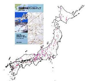
Constructing active fault database
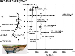
Constructing paleoseismology database
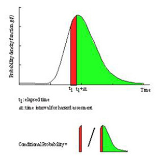
Probabilistic evaluation of earthquake occurrence by the use of renewal process
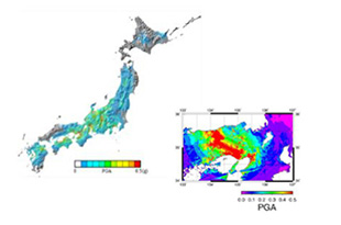
An example of the probabilistic seismic hazard map due to active faults (horizontal peak ground acceleration)
2. Constructing the probabilistic seismic hazard map due to moderate size earthquakes
The purpose of this study is to construct the probabilistic seismic hazard map for intraplate moderate size earthquakes around magnitude 6.5, such as the 2000 Tottori-ken seibu earthquake, caused by buried active faults, by using Gutenberg-Richter (GR) equation of the magnitude-frequency relationship on historical and observed seismicity data sets.
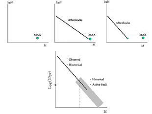
Two models of magnitude-frequency relations; individual fault and regional seismicity
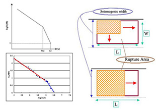
A schematic diagram of the two-segment GR model due to the limited seismogenic layer width
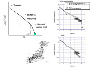
Seismotectonic map of Japan and compiled magnitude-frequency relations
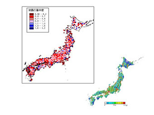
An example of the probabilistic seismic hazard map due to spatio-temporal seismicity model (horizontal peak ground acceleration)
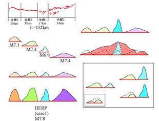
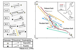
3. Strong ground motion simulation due to intraplate active faults
This project aims to simulate the strong ground motions due to intraplate large earthquake with magnitude 7.0 or over by developing the earthquake occurrence model of fault grouping/segmentation and the "Morphometric Unit Model" and to cooperate engineering seismology for earthquake risk mitigation.
Models of grouping/segmentation for seismogenic faults with several segments
An example of the "Morphometric Unit Model" and application to the Nobi fault system
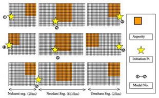
Several scenarios with asperity locations and rupture initiation points for the Nobi fault system
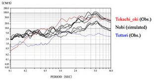
An example of the strong ground shaking simulation as response spectrum with 5% dumping
4. Constructing the model for the geomorphic evolution simulation
In order to discuss mountain uplift/erosion process, the geomorphic evolution model is developed by geomorphometric measurements with DEM and apply the results to landform classification with GIS, geology data sets, geophysical data sets and statistical methods.
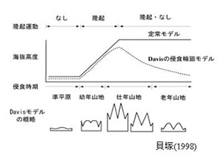
A schematic diagram of mountain uplift/erosion after Kaidsuka(1998)
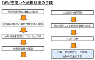
A procedure of geomorphometric studies using Digital Elevation Model
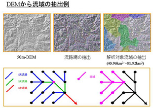
An example of drainage extraction
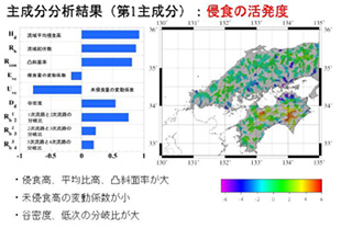
An example of statistical interpretation of geomorphometric results